In Southern California in the Salton Lake, located at 69 meters below sea level, on the San Andreas fault occurred powerful series of earthquakes with a magnitude of 2 to 5.5 - at depths of 5 to 25 km. At 22:00 - World Time, August 26, 2012 - more than 80 aftershocks. Released a powerful tectonic energy.
The earthquake occurred in Southern California in the area of card-8-Earthquake prediction for August 2012.
Zone 8 - probability-85% - 2, 4, 8, 16, 18, 22, 27, 29 / 8/2012- probability of 75% - + - 12:00-GMT.
Obviously continuing abnormal seismic activity in the region, 27 - 29 - 31 August 2012. The resonant seismic event.
Site data monitoring USMC.
Update time = Sun Aug 26 21:50:36 UTC 2012
| | MAG | UTC DATE-TIME
y / m / dh: m: s | LAT
deg | LON
deg | DEPTH
km | Region |
|---|
| MAP | 3.1 | 2012/08/26 21:46:12 | 32,996 | -115,591 | 5.12 | SOUTHERN CALIFORNIA | | MAP | 3.8 | 2012/08/26 21:26:40 | 33,038 | -115,527 | 4.12 | SOUTHERN CALIFORNIA | | MAP | 3.6 | 2012/08/26 21:23:24 | 33,005 | -115,591 | 3.14 | SOUTHERN CALIFORNIA | | MAP | 3.6 | 2012/08/26 21:23:11 | 32,973 | -115,599 | 8.5 | SOUTHERN CALIFORNIA | | MAP | 3.9 | 2012/08/26 21:17:27 | 32,986 | -115,603 | 8.11 | SOUTHERN CALIFORNIA | | MAP | 4.3 | 2012/08/26 21:15:29 | 33,033 | -115,479 | 1.12 | SOUTHERN CALIFORNIA | | MAP | 3.6 | 2012/08/26 21:08:46 | 32,997 | -115,587 | 4.11 | SOUTHERN CALIFORNIA | | MAP | 3.1 | 2012/08/26 21:06:38 | 32,966 | -115,577 | 7.13 | SOUTHERN CALIFORNIA | | MAP | 3.2 | 2012/08/26 21:06:12 | 33,005 | -115,534 | 9.2 | SOUTHERN CALIFORNIA | | MAP | 3.5 | 2012/08/26 21:05:11 | 33,001 | -115,457 | 5.1 | SOUTHERN CALIFORNIA | | MAP | 3.4 | 2012/08/26 21:04:53 | 33.020 | -115,523 | 9.4 | SOUTHERN CALIFORNIA | | MAP | 5.5 | 2012/08/26 20:57:58 | 33,024 | -115,549 | 9.0 | SOUTHERN CALIFORNIA | | MAP | 2.6 | 2012/08/26 20:45:49 | 33,030 | -115,545 | 2.12 | SOUTHERN CALIFORNIA | | MAP | 3.4 | 2012/08/26 20:34:40 | 19,646 | -64,273 | 14.0 | VIRGIN ISLANDS REGION | | MAP | 2.5 | 2012/08/26 20:33:02 | 33,008 | -115,529 | 0.8 | SOUTHERN CALIFORNIA | | MAP | 3.1 | 2012/08/26 20:31:13 | 33,024 | -115,543 | 4.7 | SOUTHERN CALIFORNIA | | MAP | 3.0 | 2012/08/26 20:30:56 | 32,938 | -115,775 | 2.12 | SOUTHERN CALIFORNIA | | MAP | 3.4 | 2012/08/26 20:20:25 | 33,026 | -115,543 | 9.11 | SOUTHERN CALIFORNIA | | MAP | 3.5 | 2012/08/26 20:16:54 | 33,012 | -115,564 | 7.12 | SOUTHERN CALIFORNIA | | MAP | 3.0 | 2012/08/26 20:14:46 | 32,996 | -115,582 | 5.12 | SOUTHERN CALIFORNIA | | MAP | 3.6 | 2012/08/26 19:58:17 | 33,025 | -115,541 | 6.13 | SOUTHERN CALIFORNIA | | MAP | 3.4 | 2012/08/26 19:50:15 | 33,007 | -115,586 | 8.12 | SOUTHERN CALIFORNIA | | MAP | 3.2 | 2012/08/26 19:45:56 | 32,993 | -115,575 | 0.2 | SOUTHERN CALIFORNIA | | MAP | 3.0 | 2012/08/26 19:43:41 | 33,023 | -115,541 | 6.10 | SOUTHERN CALIFORNIA | | MAP | 4.3 | 2012/08/26 19:40:13 | 32,990 | -115,598 | 8.13 | SOUTHERN CALIFORNIA | | MAP | 3.4 | 2012/08/26 19:35:52 | 32.995 | -115,485 | 7.9 | SOUTHERN CALIFORNIA | | MAP | 4.9 | 2012/08/26 19:33:01 | 33,021 | -115,554 | 5.14 | SOUTHERN CALIFORNIA | | MAP | 5.3 | 2012/08/26 19:31:23 | 33,019 | -115,546 | 3.12 | SOUTHERN CALIFORNIA | | MAP | 2.6 | 2012/08/26 19:30:55 | 33,035 | -115,536 | 2.10 | SOUTHERN CALIFORNIA | | MAP | 3.4 | 2012/08/26 19:28:45 | 33,023 | -115,561 | 7.13 | SOUTHERN CALIFORNIA | | MAP | 3.4 | 2012/08/26 19:28:36 | 33,021 | -115,564 | 5.12 | SOUTHERN CALIFORNIA | | MAP | 3.5 | 2012/08/26 19:21:04 | 33,003 | -115,546 | 11.0 | SOUTHERN CALIFORNIA | | MAP | 4.6 | 2012/08/26 19:20:05 | 33,019 | -115,545 | 1.13 | SOUTHERN CALIFORNIA |
Illustrations from the program Earthquake3D.
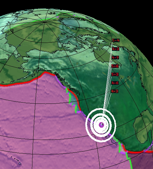
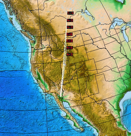
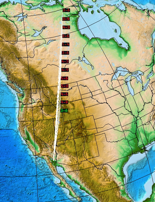
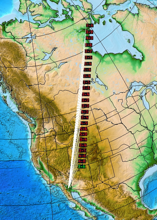
A series of earthquakes in Southern California, August 26, 2012.
The report, "The earthquake in Los Angeles, August 8, 2012," it was said:
Formed
tight configuration with the transit of Venus squaring Uranus-Pluto,
backhaul Mars and Saturn in the projection on the U.S. horoscope.
The most intense period of growth of the seismic-14 - August 18, 2012.
During
this period, the San Andreas Fault in California, in seismically active
regions in the U.S. are likely stressful, dangerous seismic event with magnitude greater than 6.
Accumulation
effect cosmological factor, cosmic energy and gravitational waves to
the region of California, the San Andreas Fault triggered by 9 days
after the New Moon, August 17, 2012.
But
the fact remains that, under the forces of the cosmos to the geosphere
Earth in California a seismic anomaly-release enormous tectonic energy.
Research linking seismic activity, volcanic activity, intense
manifestations of the elements with space factor, the gravitational
fields of the method are carried out in "Astrology as a security system." Software- astroprocessor ZET GEO.
By the method, Andrei Andreev, kosmoritmolog.
Post- "Earthquake in Northern California, May 5, 2012. suffer a" golden state "the fate of Atlantis?"
Site data monitoring EMSC.
 |